| El Morro means "the headland," and refers to an ancient
landmark which is famous for its inscriptions and ruins.Many Spaniards passed through the American Southwest region looking for gold,
fame, the Seven Cities of Cibola, and other wonders and riches
to conquer and plunder. Many of their names are also inscribed
here.
El
Morro National Monument is located in Northwestern New Mexico.
The
oldest Spanish inscription dates to 1605. It reads: "Paso por
aqui el adelantado Don Juan de Oñate del descubrimiento
de la mar del sur a 16 de Abril de 1605." In English, this translates
to: "Passed by here the Governor Don Juan de Oñate from
the discovery of the Sea of the South the 16th of April of
1605." The adelantado was considered the individual with the
highest military, political, and judicial powers at the time
of the Spanish conquest. This inscription is roughly 400 years
old.
Another
famous inscription is from Don Diego de Vargas. This inscription
is important due to the history of the site. The inscription
reads "Aquí estuvo de general Don Diego de Vargas, quien
conquisto a nuestra Santa Fe y a la Real Corona todo el Nuevo
Mexico a su costa, Año de 1692." Translated this reads
"Here was General Don Diego de Vargas who conquered for our
Holy Faith, and the Royal Crown, all of New Mexico at his
own cost/expense year of 1692." This is an impressive statement
considering that fact that approximately twelve years prior
(1680,) the Pueblo Revolt took place and the Spaniards were
driven from the area. The Spaniards that survived fled to
El Paso. In 1692, de Vargas returned to establish control over
the pueblos. The Spanish were able to avoid conflict with
the Zuni on this occasion. The Zuni however kept their defensive
position on Dowa Yalanne, a mesa, until 1699 when they felt
safe from Spanish retaliation.
The Spaniards were never able to really convert the Pueblos; instead they were pretty much just barely tolerated by the Zuni and Hopi. The
Zuni seemed to use the Spaniards when they needed them to join an alliance against the Apaches and the Navajo.
This while Spanish records mention the Zuni took place in
the Pueblo Revolt (1680).
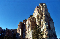
El
Morro contains many inscriptions. Many of these date to the
1600s, 1700s, and 1800s. The petroglyphs are the oldest
"inscriptions" and are estimated to be 700-800 years
old.
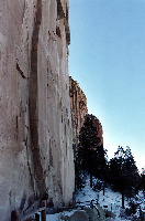
There
are two trails in the park. The first is the Inscription Rock
Loop trail. The second is the Mesa Top Loop trail. The Inscription
Rock trail contains the famous "signatures and dates"
that El Morro is famous for. It is 1/2 of a mile round-trip
and includes the pool of water. The Mesa Top Loop trail is
two miles round trip and goes to the top of the mesa. Here
visitors will see the remnants of two ancient Anasazi pueblos.
The larger of the two, A'ts'ina, was excavated in the 1950's.
The other (smaller of the two) has yet to be excavated. Please
stay on the trail, the mesa top has cliffs that drop off for
200+ ft.
Atsinna
Ruin contains a square kiva. The ruin is believed to have
been two to three stories in height and the size of a small
city block. It was inhabited by the Anasazi and commanded
quite a view. The park is located in the high deserts of the
Southwest at an elevation of 6,000-7,500 ft. The mesa itself
and the ruins are at approximately 7,500 ft. The visitors
center is 7,218 ft.
Location: Northwestern
New Mexico. Along US 53, approximately 2.5 hours from Albuquerque,
New Mexico. From Grants, New Mexico go southwest on highway
53 for approximately 43 miles. Follow the signs when you get
into the area. By todays standards it is a bit out of the
way. Anciently it was a major thoroughfare, in part as it
contained a precious source of water. Take appropriate cautions
when necessary, i.e. never cross a flooded wash, watch for
flash floods if it is raining anywhere in the region, watch
for deer, cows, and horses, etc. etc.
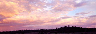
Weather: This is high altitude. Conditions can change rapidly. Please
observe all warning signs. Thunderstorms with lightning can
be extremely dangerous. With inclement weather, roads and
trails can become impassible.
Other
areas of interest in the area include Hawikuh, Acoma (Sky Pueblo),
El Malpais National Monument, Zuni, Chaco Canyon, and many other sites. |