| Chaco Canyon
is located in Northwestern New Mexico, about as close to the
edge of nowhere as one can get. Roads into the park are not
paved — and quite rough — although the roads inside
the park boundaries are paved. The effect of these rough roads is to discourage the casual tourists. You really have to want to see the park to drive there, and it is certainly not on the way to anywhere.
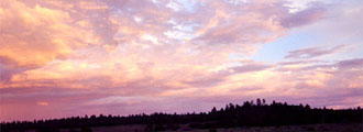
The
Chaco Canyon area was inhabited by the Anasazi. The park is
located in the high deserts of the Southwest at an elevation
of 6,000-7,000 ft. Chaco
Canyon is a very unique place. Several ancient roads converge
here, indicating that this was a center for trade. There are
whole cities in the area which have yet to be excavated. It
is estimated that over 300 hundred pueblos and storehouses
line a 10 mile stretch of the Canyon.
Ruins
inside the park include:
Penasco Blanco, Casa Chiquita, Kin Kletso, Pueblo Alto, Rabbit
Ruin, Pueblo Bonito, Pueblo del Arroyo. Chetro Ketl, Casa
Rinconada, Tsin Kletsin, Hungo Pavi, Una Vida, Pueblo Alto,
New Alto, and Wijiji.
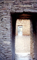
Pueblo
Bonito has a unique "D" shape and was excavated
by the Smithsonian Institute. A number of impressive items such as pottery
caches (including cylindrical jars), flutes, yucca sandals,
jewelry, stone effigies, arrows, and prayer sticks have been
excavated here. Archeologists estimate that Pueblo Bonito
had more than 600 rooms.
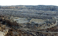
Chetro
Ketl is noted for its great kiva and its tower kiva which
is a distinctive structure.
Casa
Rinconada has a great kiva that is aligned precisely with
celestial north. The largest kiva in the area, it also has
hidden entrances, which may have allowed religious leader
to make dramatic, if not magical, entrances.
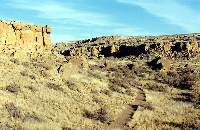
Various
ancient stairways are also found throughout Chaco Canyon.
If you are adventurous, you can hike the ancient trails, checking
out the Jackson Stairway, as long as you have a backcountry
permit. You could also see the small diversion dams and canals.
Other
unique features in the area include pictographs, which are
believed to depict the supernova explosion which occurred
in 1054 AD.
Chaco
has a lot to offer to the enthusiast who loves the more remote
areas of the US. If you can make it over the rough roads to
the park, there is a lot to see and experience.
Location: Northwestern
New Mexico. As close to the middle of nowhere as it is possible
to get. Northeast of Gallup, New Mexico. Southwest of Farmington,
New Mexico. 60 miles north of I-40. Note: Roads leading into
the park are not paved. Roads inside the park itself are.
Take appropriate cautions when necessary, i.e. never cross
a flooded wash, watch for flash floods if it is raining anywhere
in the region, watch for deer, cows, and horses, etc.
Weather: This is high altitude. Conditions can change rapidly. Please observe
all warning signs. Thunderstorms with lightning can be extremely
dangerous. With, inclement weather, roads and trails can become
impassible. |