| El
Malpais (Spanish for badlands) National Monument is located
in Northwestern New Mexico. The badlands are volcanic lava
flows, and they extend for miles. The badlands consist of
volcanic spatter cones, mesas, lava flows, ice caves, an arch
or two, petroglyphs, ruins, and lava tube caves. One such
cave system is 17 miles long. Please note, the area known
as El Malpais is a combination of private lands, wilderness,
BLM, and National Monument. Admission is free. Please respect the private lands.
Highway
117 has the Sandstone Bluffs Overlook, the La Ventana Natural
Arch, the Narrows, Lava Falls area, and the Zuni-Acoma Trail.
The
Sandstone Bluffs are a viewpoint. An easy drive goes to the
top and has impressive views of the area.
La Ventana Natural Arch is one of New Mexico's largest arches.
A short trail goes under the sandstone arch. The Narrows is
a location where lava flowed near 500 ft. cliffs.
The Lava Falls area is the youngest lava flow in the area.
The Zuni-Acoma trail is a 7.5-9 mile trail (each way) that
crosses four lava flows. It lies between Highways 53 and Highway
117.
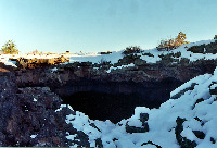
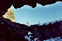
Highway
53 has the Bandera Crater Ice Caves (private) , the Big Tubes
area, El Calderon area, and the Zuni Acoma trail. The Big
Tubes area is in the back country.
The
best advertised ice caves are on private property, and, while
they sound exciting, they are primarily lava tubes with ice
in them year-around.
The
Big Tubes area is located in the back country and consists
of approximately 17 miles of lava tubes. Some of these contain
collapsed sections. Caution should be exercised while in this
and other areas. There is a route between two caves, Big Skylight
and Four Windows, which is marked by cairns. Please see the visitor's
center for more information.
The El Calderon area is a unique area which is easily accessed.
A trail leads to Junction Cave, Twin Craters, Lava Flow Double
Sinks, the El Calderon cinder cave, and a cave with bats.
Junction Cave has a small trail between 2 other caves. The
area also contains some sink holes, a cave with bats (please
do not enter).
The Zuni-Acoma trail is a 7.5-9 mile trail (each way) that
crosses four lava flows. It lies between Highways 53 and Highway
117 .
Other
items of interest in the area include the Dittert Site (Ruin),
petroglyphs, hole in the wall, continental divide trail, chain
of craters, and various volcanic cones that are scattered
across the region.
The
area has different types of lava flows. Rangers can teach
you about these.
Please exercise caution while in the area. BE SAFE! Let others
know where you are going and when you are expected back. People
have disappeared from here (Big Tubes area). They have yet
to be found.
If plans are made to hike in the caves, it is strongly recommended
that ample food, water, clothing (they are cold), and light
sources be carried. It is recommended that visitors carry
a minimum of 3 light sources per individual. Please let others
know where you are going. Some of these areas have collapsed.
Caution should be taken while here.
Location: Northwestern
New Mexico. South and east of Gallup, New Mexico. It is between
Gallup and Albuquerque. It is bordered on the east by Acoma
and on the west by Ramah (Navajo). The Cibola National Forest
is on the north. Highway 53 is on the north. Highway 117 is
on the east side. The National Park Service has a visitors
center 23 miles south of I-40 on Highway 53. The BLM (Bureau
of Land Management) has a visitors center 9 miles south of
I-40 on Highway 117. Take appropriate cautions when necessary,
i.e. never cross a flooded wash, watch for flash floods if
it is raining anywhere in the region, watch for deer, cows,
and horses, etc.
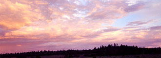
Weather: This is high altitude. Conditions can change rapidly. Please observe
all warning signs. Thunderstorms with lightning can be extremely
dangerous. With, inclement weather, roads and trails can become
impassible.
|