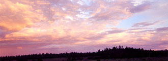
| Located
close to the heart of Phoenix is one of Phoenix's best known
landmarks, Piestewa Peak, formerly known as Squaw Peak. The
Piestewa Peak trail is a short but moderate to difficult hike, and is a favorite for many people in the Phoenix area. At 2.4
miles roundtrip it is a great hike for families and others
who want to do something local but have limited time. Hikers
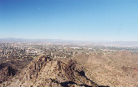
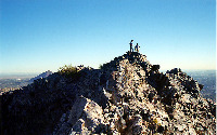
who reach the summit are rewarded with stunning views of Metro
Phoenix.
Many
hikers and joggers use this trail for exercise as well as
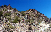
preparation for longer hikes. The steep and rocky trail is
primarily Precambrian schist. Along the way visitors will notice a number of desert plants
such as saguaros, ocotillos, barrel cacti, palo verdes, and
more.
The
starting elevation is 1,400 ft. Elevation at the summit is
2,608 ft. With a difference of 1,208 ft and 1.2 miles each
way, this makes for an elevation gain of approximately 1,000
ft. per mile, or one short but somewhat steep trail.
The
trail starts near the first ramada and begins switchbacking
up the mountain. Other than a few relatively straight stretches,
the entire trail is pretty much a series of switchbacks. Views
from the summit are impressive. Try testing your knowledge
of the Valley's landmarks from the summit. It is also possible
to see South Mountain, the McDowells, Superstitions, Sierra
Estrellas, and the White Tank Mountains — pretty much all of
the mountains that surround the valley.
An
additional point of interest is the Piestewa Peak Circumference
Trail. Instead of going up the mountain, this trail goes around
it.
Climate: Keep in mind this is the Sonoran Desert. Temperatures easily
exceed 110 degrees Fahrenheit (or 43 degrees Celsius) in the
summer. Rattlesnakes, scorpions, and Gila monsters are active
in this environment. Watch for lightning storms as well. It
is highly recommended that hikers carry plenty
of water.
Location: The trail is well-used and relatively
easy to find. Take Lincoln Drive to Squaw Peak Drive. Follow
this to the ramadas. The trailhead is on the north side, close
to the first ramada. Facilities in the area include electricity,
restrooms, tables, and parking spaces.
|