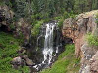
Pacheta
Falls is located just downstream of the confluence of Ess Creek
and Pacheta Creek. A short distance from the junction of the
two creeks, Pacheta Creek tumbles 131 ft. into a canyon lined
with sheer cliff walls, and continues on its journey to the
Black River.
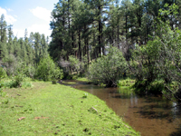
The
scenery enroute to to the falls is spectacular. The trail
from the main road follows Pacheta Creek for 1.5 miles downstream
before reaching the falls. Enroute, the trail passes through
a Ponderosa Pine forest interspersed with Douglas Fir, and
crosses several meadows.
There
are at least two routes to Pacheta Falls: a short route through
the forest off the end of an old logging road (good luck finding
this); or a 3.0 mile roundtrip hike from the main road. The
hike from the main road follows the stream downriver. If you
choose to follow the stream, the route is pretty flat, and
you should start your hike on the right (West) side of the
stream. The trail is faint and in some places non-existent,
but as long as you stick to the creek you should not get lost.
(Assuming you are actually following Pacheta Creek.) Just
prior to reaching the falls, you should be able to hear the
roar of the water. If you have not already done so, cross
over to the east side of the stream prior to reaching the
falls, or you will end up on some pretty rough cliffs. You
should cross the stream any place you like after Ess Creek
joins Pacheta Creek in a broad meadow.
The
falls are very picturesque, with lovely greenery and tumbled
rocks. They are viewed from above, from viewpoints just down
from where the stream falls off into a canyon about two miles
north of the Black River. You would need climbing gear and
technical rock climbing experience to descend into the canyon
to the base of the falls. Caution should be exercised near
the falls, since there are no handrails to help you if you
take a tumble. Children should be kept close and away from
any cliff edges at all times.
Note:
This is high, wild, rugged country. Finding the trailhead
could be a challenge. Pacheta Creek is not marked on the road,
so make sure you have accurate, up-to-date maps and directions.
The Falls are not marked, and the trailhead is not marked,
nor even visible from the road. All of this helps to ensure
the pristine condition of the falls, so please take care with
how you treat the area.
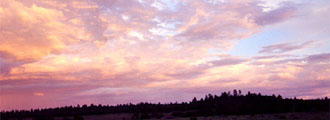
This
is high country, with an elevation of approximately 7,300
ft. During the summer monsoon, and at other times, afternoon
thunderstorms can be frequent. Hikers should be prepared for
conditions. The author and his family got thoroughly soaked
by one such storm while hiking (running) back to the car.
The
falls are located in a remote section of the White Mountain
Apache Reservation. Since the falls are not marked on many
maps, finding it required a combination of three maps. There
is a long drive on primitive roads. A passenger car can make
it back to the trailhead, but not if the road condition deteriorates
further. Special
Permits are required and must be obtained in advance from the White Mountain Apache
Tribe. You can buy these at the Hon-dah Outdoor & Ski
Shop, and other approved locations in Arizona. Directions,
maps, and route finding skills are strongly recommended. |